Spatial Analysis of Vehicular Emission Pollution in Macau Pe
| 论文类型 | 基础研究 | 发表日期 | 2005-10-01 |
| 来源 | Macau Environment and City Development 2002 | ||
| 作者 | U,Wa,Tang,Zhishi,Wan | ||
| 关键词 | urban spatial data dispersion air pollution GIS | ||
| 摘要 | GIS (Geographical Information System) is a newly powerful tool for environmental assessment and analysis since the quality of environment is highly related to the "geographical" related factors. GIS can integrate such factors as "information" stored in a | ||
Macau Environment and City Development 2002
Spatial Analysis of Vehicular Emission Pollution in Macau Peninsula
U Wa Tang, Zhishi Wang
(Faculty of Science and Technology, University of Macau)
Abstract: GIS (Geographical Information System) is a newly powerful tool for environmental assessment and analysis since the quality of environment is highly related to the "geographical" related factors. GIS can integrate such factors as "information" stored in a database within a "system" for better analysis. This article is focus on finding the spatial relationship between vehicle-dominated air quality and its geographical constrain, so called the street canyon effect in Macao peninsula. Spatial patterns of NO, NO2, CO as well as canyon levels were modeled in front of each building block in main streets of Macao peninsula and apparent spatial relationships were found. Such findings verifies the significance of street canyon effect as an indicator for air quality assessment as well as a control parameter for urban planning which can contribute the decision making process for our government.
Keywords: urban spatial data, dispersion, air pollution, GIS
1. Introduction
Nowadays air quality of a city is reported according to the data collected from fixed monitoring stations at various functional areas such as the industrial area, residential area, road-side situation, as well as urban and suburban area etc. It may be suitable for simple geographic conditions where dispersion condition is simple. However, in urban area, such as Macao peninsula, with various microenvironments because of the difference of height of buildings and the complex traffic emission, one roadside monitoring station is insufficient to represent the whole function area.
A new approach using modeling technique to access air quality in front of each building block besides the main streets of Macao peninsula was targeted in this research. Evaluating suitable model under situations of Macao and then run all model cases automatically were the main stages. As traffic jam condition and street canyon dispersion condition are the two main characteristics controlling the air quality in Macao, two corresponding widely used mathematical dispersion models were then chosen for evaluation. Afterwards, it is clearly impossible to prepare all input spatial data files for each building block manually as there are more than 400 cases in Macao peninsula. GIS was then utilized successfully to overcome such time-consuming and human-error-inducing stage. Finally, the pattern of air quality in Macao peninsula was found varies according to its street canyon geometry.
2. Evaluation of Dispersion Models
There are many dispersion models with different complexity and different levels involving urban spatial data. Two models, CAL3QHC and OSPM, were evaluated. They represent different approaches of emission estimation and dispersion prediction for US and Europe urban situations. Comparison of them was given according to BERKOWICZ et al (1997), PAUL (1979) and US EPA (1995).
2.1. Comparison of Geographical Consideration
As CAL3QHC estimated the pollutant at intersection, geometry of all intersection lanes were involved. A serious of receptors could be placed along the side of lanes. The height and location of the surrounding building blocks were not necessary and a user specified surface roughness coefficient was used. The range was from 0.03cm to 370cm representing smooth surface to residential apartment conditions. The dispersion estimation was based on the flat surface geographical environment.
OSPM focused on estimating a single urban canyon street. Only two receptors were used to represent the condition of windward side and leeward side in front of the study building block. The input parameters included the heights and locations of all nearby building block as well as the direction of the studying street. OSPM required more detail spatial data and hence, as shown later, proved to be more sensitive than CAL3QHC.
2.2. Comparison of Traffic Flow and Emission Estimation
CAL3QHC had a good improvement for estimation of the emission, which was separated into two parts at the intersection in signal junction by using the method in the Highway Capacity Manual in US. One was the emission from free flow condition during the green signal. The emission factor was user specified, which was modeled by Mobile 5 program of EPA according to the speed condition etc. Another was the queue condition during the red signal. By the approach traffic flow, the growing of the queue lane was estimated and the emission was calculated by the specified idle emission factor, which is much larger than the classical free flow emission factor. Estimation was hence carried on under the approach condition and the Under-Saturated/Over-Saturated Conditions.
OSPM did not require inputting the idle emission factor for the queue lane concept was not applicable here. However, the hourly average speed of the vehicle was needed and the corresponding emission variation for each type of vehicles was then adjusted.
2.3. Comparison of Dispersion Component
The dispersion component used in CAL3QHC was CALINE-3. CALINE-3 estimated air pollutant concentrations resulting from moving vehicles on a roadway based on the assumptions that pollutants emitted from motor vehicles traveling along a segment of roadway can be represented as a "line source" of emissions, and that pollutants were treated as dispersing in a Gaussian distribution from a defined "mixing zone" over the roadway being modeled.
OSPM used a simplified parameterization of flow and dispersion conditions in a street canyon that was deduced from extensive analysis of experimental data and model tests under different street configurations and a variety of meteorological conditions.
Concentrations of exhaust gases are calculated using a combination of a plume model for the direct contribution and a box model for the re-circulating part of the pollutants in the street.
That is, Cd and Cr are calculated separately as, Cst = Cd + Cr
Where Cst is the total concentration; Cd is the direct gauss plume dispersion by traffic emission; Cr is the recirculating part of the pollutants in the street.
2.4. Comparison of Model Results
Totally 3431 hours of monitor data from Aug. 1999 to Aug. 2000, excluding non-working days, were used to evaluate the dispersion model CAL3QHC and OSPM. Half-day monitor CO data from midnight to noon was shown in Fig.2. A clear pattern was shown that in 1-7 a.m. the minimum concentration was around 0.5 ppm and variation was less. After 7 a.m. the base line suddenly rose to 1 ppm and maintained in the following period with high variation. Such behavior was closely related to the traffic loading condition. Comparing to the CAL3QHC model values, a correlation of 0.46 was adopted. It was shown that the distribution of the modeled points lay lower than the monitor data in general. It is probably due to the model assumes flat topography as in highway typically found in US.
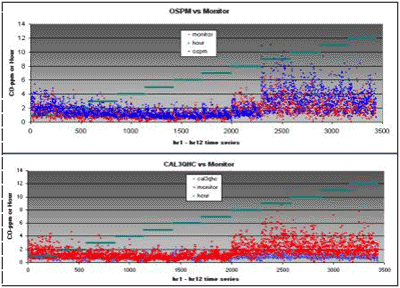
Figure 1 One year monitor vs. model pollutants by CAL3QHC and OSPM in hourly time series
For OSPM, although real time traffic-count data were not available and only substituted by a typical profile, relative good correlation was found between the modeled and the measured concentrations in both CO and NOx. Fig.1 showed that OSPM behaved well in predicting the minimum and highest concentration in general. The correlation coefficient of model and monitor for CO and NOx were 0.62 and 0.63.
Although CAL3QHC considered more in traffic jammed condition, the about results showed that utilization of the height of building and width of street spatial data with corresponding wind tunnel deduced dispersion parameters by OSPM was more sensitive.
2.5. GIS and OSPM Connection
The conceptual framework for this GIS/OSPM connection allowed programs within GIS to produce the necessary information for the input file of exterior model OSPM. The ArcView GIS software then executed user written internal program in order to obtain a properly spaced input file and executed the model. Finally, the model output was processed, imported back into GIS, and viewed as charts, tables, and coverages. Specifically for this research, the model input is read by the ArcView programming language Avenue from tables and coverages

Figure 2 Process of integration OSPM in GIS
3. Pollutant Distribution
Hourly NOx and CO concentrations accepted at roadside human height level were modeled under the normal condition of summer season in Macao. The classification of pollutant levels in the GIS coverage was according to national standard. As tourism industry is an exclusive economical sector in Macao, fulfilling type 1 standard is the ultimate goal. The result in Fig. 3, 4 showed that all the studied NOx values (represented by NO2) and CO values were satisfied national type 1 requirements under the model situation.
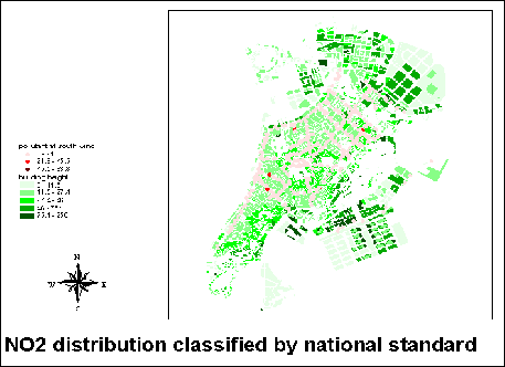
Figure 3 NOx classified by national standard, south wind direction
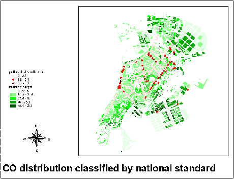
Figure 4 CO classified by national standard, south wind direction
4. Analysis of Geographic Influence on Air Quality
Although traffic flow is an important factor as it dominates the source of pollutant, the highest pollutant zones did not lay within the highest traffic flow areas as shown in Figure 6. Different levels of total traffic flows were distinguished by the color and the elevation. Coincided with what we commonly familiar with, the main street coded (Fig. 5) as 41, 38, 16, 25 and 3 to 10 serve a large amount of circulation while the central of peninsula is in low traffic flow intensity. However, this central area had a higher NOx in general.
The reason could be discovered by Fig.8. In order to examine distribution of the street canyon chrematistic, H:W ratio (Height of building : Width of street) was displayed in front of each building block. Higher ratio implemented more serious of the street canyon effect and more difficult to disperse traffic pollutant. Five levels were classified in this figure using the natural-breaks method. An interesting finding was that the lowest H:W ratio existed round the boarder such as the west coast while the highest H:W ratio distributed at the central of peninsula. Hence, NOx concentration was higher around the old district at the center of peninsula canyon with low traffic loading.
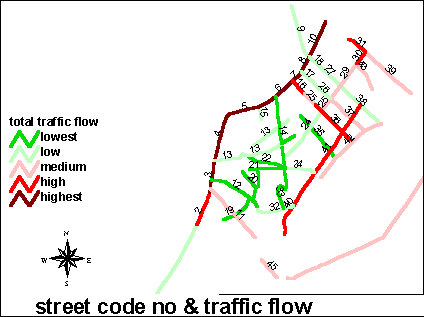
Figure 5 Total traffic flow comparison
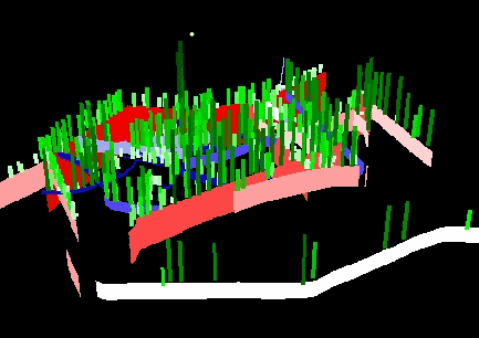
Figure 6 A 3D view of NOx distribution vs. traffic flow
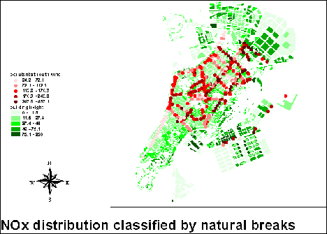
Figure 7 NOx concentration distribution
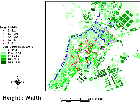
Figure 8 Intensity of street canyon
The finding of the roadside air quality highly related to the urban spatial characteristics has a significant meaning for the substantial urban development of Macao peninsula.
Reference
BERKOWICZ R, HERTEL O, LARSEN S E, SORENSEN N N et al (1997) Modeling traffic pollution in streets. National Environmental Research Institute, Roskilde, Denmark 52
CHEN Cai, WANG ZhiShi, WANG Xinming, TANG U Wa et al (2000) Volatile Organic Compounds in Ambient Air in Macao, Research Report: Environmental Assessment of Vehicular Exhaustion Emission Pollution in Urban Areas of Macao, pp32-39
HAO Jiming, Wang Zhishi, HE Dongquan et al (2000) Spatial Distribution of Vehicular Emssion in Macau Air, Research Report: Environmental Assessment of Vehicular Exhaustion Emission Pollution in Urban Areas of Macao, pp111-123
LIU Baozhang, LIN Guanming, KANG Ling (2000) Aerodynamic Tests for the Typical Street of Macau, Research Report: Environmental Assessment of Vehicular Exhaustion Emission Pollution in Urban Areas of Macao, pp82-97
MAGUIRE David J, GOODCHILD Michael F and RHIND David W (1991) Geographical Information Systems, Principle and Applications, Longman Science & Technical
PAUL E Bension (1979) CALINE3-A Versatile Dispersion Model for Predicting Air Pollution Levels Near Highways and Arterial Streets, Office of Transportation Laboratory, California Department of Transportation
TANG U Wa, WANG Zhishi (2000) Environmental Information System for Government Services, Macau IT 2000 Congress
US EPA (1995), User‘s Guide to CAL3QHC Version 2.0: A Modeling Methodology for Predicting Pollutant Concentrations Near Roadway Intersections, US Environmental Protection Agency
close
www.h2o-china.com论文搜索
月热点论文
论文投稿
很多时候您的文章总是无缘变成铅字。研究做到关键时,试验有了起色时,是不是想和同行探讨一下,工作中有了心得,您是不是很想与人分享,那么不要只是默默工作了,写下来吧!投稿时,请以附件形式发至 paper@h2o-china.com ,请注明论文投稿。一旦采用,我们会为您增加100枚金币。